The Pacific Crest Trail I
The Pacific Crest Trail is a long distance hiking trail in the United States. It winds it's way through the whole country from the Canadian to the Mexican border, crossing Washington, Oregon and California. The total distance amps up to a whopping 4720km, which is quite intimidating if you consider that it is a wilderness trail. This means you will carry all your gear and supplies on your back, sleep in a tent, wear the same clothes for 5-10 days at a time, filter water from streams and eat solely what you find in your backpack.
Every 5-10 days, depending on the sections, you will hit a town or hitchhike from the trail into a nearby town. This will be the time to do laundry, shower, eat real food and resupply.
Sounds quiet daunting, right? This did not put me off though. For about 2 years I was planning, prepping, acquiring and testing gear, and saving as much money as I could.
The process to get into the PCT can be a lengthy one, from the struggle to get a permit to letting go of your flat, your job and storing your whole life away. This is necessary since the trail can take up to 6 month to complete.
I went through all of that and eventually flew out to the states in July 2022, on my own, on my biggest adventure to date.
The Beginning
As soon as I landed in Seattle I met Laura, who was a fellow hiker who I had connected with in advance over social media. We shared a room for the first few days while we were trying to get everything organised to start our big adventure.

I remember one evening where we both had 16 days of food spread out around us, organising it into our resupply boxes that we would ship ahead of ourselves. Those boxes would sustain us in the state of Washington as the trail towns there are quiet rural small communities with little or no shops at all. This was pretty daunting since we both were unsure about what we would need down the line and we were both total noobs when it comes to long distance wilderness hiking.
Once we were roughly (very roughly) organised, we had to figure out how the hell we would get to Hart's pass - the starting point for all southbound PCT hikers. Hart's Pass is more than a 4 hour drive away from Seattle and there is no straight forward route by public transport.
Luckily we connected with Hilde - another PCT hiker to be, who invited us over to her family home. They hosted us for the night and her Mam Kirsti drove us all out to Hart's Pass the following day. I felt incredibly spoilt by Hilde and her parents. They took time to show us around Seattle, hosted us, made sure we had everything we needed and then drove us the full 4 hours. I can't thank them enough.

On our way up to Hart's Pass we came across a lone hiker in a bright red skirt, trotting up the mountain road. We quickly offered her a lift and with that Eileen had joined our little hiker group.
The Snow
Man, was I not prepared for what was to come. I thought I had a pretty good idea and was reasonably prepared and fit. Oh boy, was I wrong.
My start date was the 10th of July, so by this time the North Cascades are mostly snow free - normally. It hadn't been a normal year, in fact it had been the highest snow year the North Cascades have seen in 80 years.

I was dramatically unprepared for the conditions. With no former snow experience and a newly purchased ice axe, me and my hiking pals were travelling over mountain passes and steep snowy mountain crossings. I. Was. Terrified.
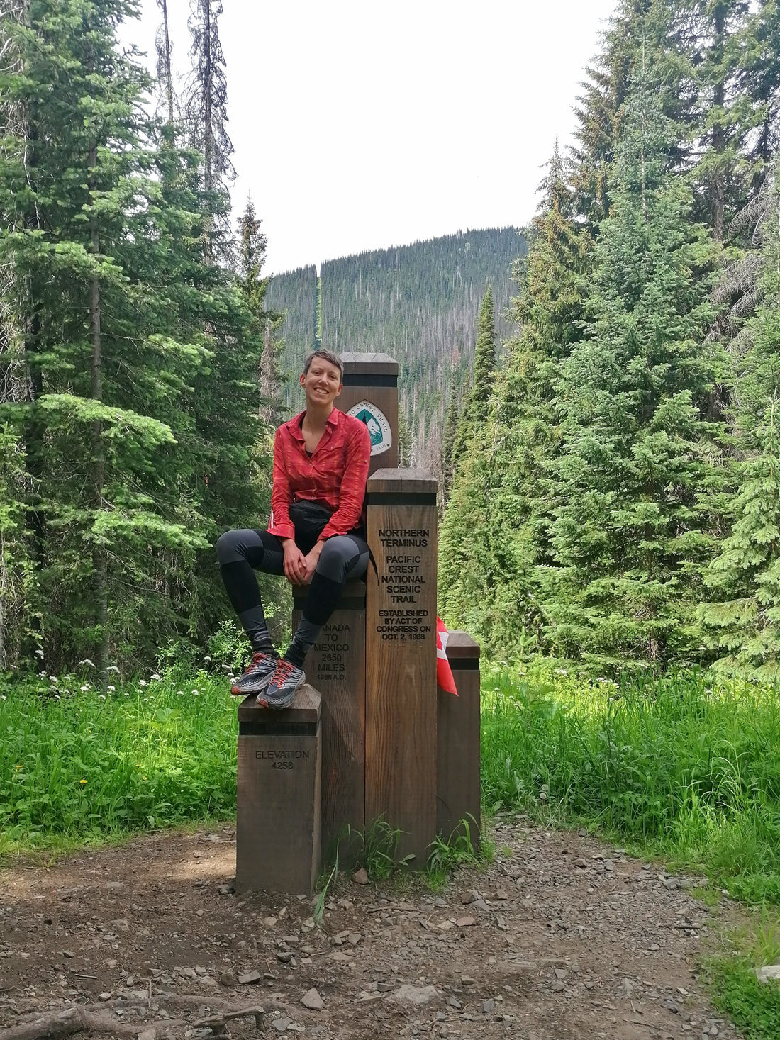
To make it to the northernmost point of the PCT, we had to hike 3 days out towards the Canadian border and then hike all the way back. So we were quite committed after two days. Especially since the snow crossings were a lot and we didn't want to do them again on the way back. We found an alternate route, the Robinson Creek Trail, which would take us back to Hart's Pass in lower elevation and therefore hopefully snow free.
After nearly killing myself a few times in the snow we made it finally to the northern Terminus and took our pictures (you can see mine on the top of this page - I already look exhausted).
The alternate route proved to be mainly snow free and it was pure bliss. The only thing that tinted the joy of not having to fear for my life constantly was the blow downs - trees that had fallen down over the trail, in some sections completely burying it for a couple of miles. I have never been that scratched up and bruised in my whole life.
As we were nearing Hart's Pass again to truly begin our journey southbound we all had to evaluate how we would proceed, considering the amount of snow still lingering. I decided to catch a ride back to Seattle and flip down to Redding in Northern California. I knew it would be hot there, but I had no Idea how hot it was going to be. All I knew was there wouldn't be any snow. I would continue to walk north from there, hit Hart's Pass again, fly back into Redding and walk the rest of the trail south from there. At least that was the plan.
On our last Mountain pass before Hart's Pass we took this picture together .

From left to right:
Hilde, Eileen, Me, Laura
Things went totally different than I had planned or expected them to go already, but I should soon find out, that this was just the nature of this adventure.
Read more in Part II